 |
| via: West8 |

12.27.2011
12.19.2011
Defining characteristics
Diagrammatic collage-drawing dealing with a few keywords within the project
-Vertical
-Hanging
-Light
-Rhythmic enclosure
-Clinging space
-Reaching or Stretching


Topographic drawing
-defining territory
-looking at strategic positioning
-creating a pattern for programming possibilities

-looking at strategic positioning
-creating a pattern for programming possibilities
drawn by hand with ink and marker, added vector lines in illustrator

12.13.2011

12.12.2011
the President's Medals 2011
New projects up on the President's Medals Student Awards' website. It's always nice to browse through.
Here is an example of a nice project:
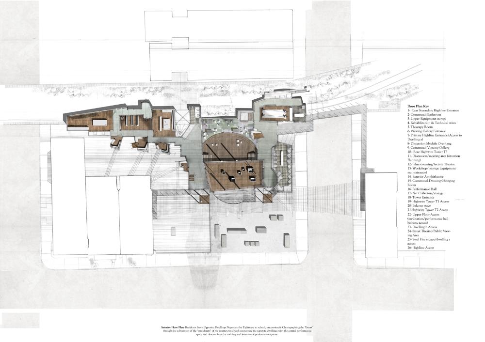
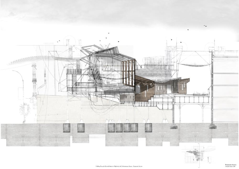
Highlines Of New York; Chelsea School Of Aerial Arts by Adam Shapland
Here is an example of a nice project:
Highlines Of New York; Chelsea School Of Aerial Arts by Adam Shapland
 |
| via: President's Medals |

12.10.2011
Amsterdam central town elevation
I've spent the last day on measuring building hight in the central area of Amsterdam.
This elevation only depict buildings taller than 40 meter
12.09.2011
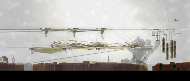
Navigating through the archipelago
The grid is made up by a number of hyper-rational structures.
Inspired by Amsterdams historical growth where water has been covered up to fit more buildings, the new mega structure roots itself in the canals as it is hoisted up. Where ever it connects vertically an island appears in the artificial urban archipelago. The islands reaches out with its bridges and sends away its boats who weaves the grid together.

Inspired by Amsterdams historical growth where water has been covered up to fit more buildings, the new mega structure roots itself in the canals as it is hoisted up. Where ever it connects vertically an island appears in the artificial urban archipelago. The islands reaches out with its bridges and sends away its boats who weaves the grid together.

12.08.2011


12.07.2011


12.05.2011
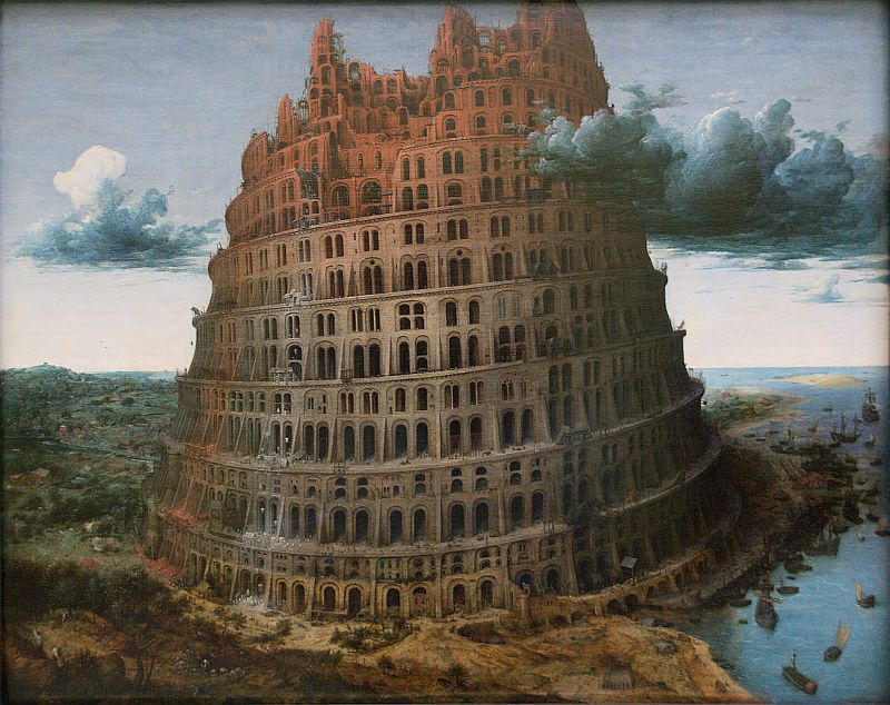
Stan Allen | Landform building
I got this book the other day. Once again great reading from Allen.
He guides us through the field of vast built structures within the frame of four main topics; form, scale, atmosphere and process. These topics are examined in discussion and interview, as well as relevant case studies, with everything from the Tower of Babel to Ishigami's Kait Kanagawa Institute of Technology.
He guides us through the field of vast built structures within the frame of four main topics; form, scale, atmosphere and process. These topics are examined in discussion and interview, as well as relevant case studies, with everything from the Tower of Babel to Ishigami's Kait Kanagawa Institute of Technology.
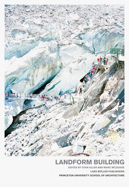 |
ISBN-10: 3037782234
ISBN-13: 978-3037782231
|
12.01.2011
Sketchbook pt.1
I got the Architects' Sketchbook from my parents for my 30th birthday, last wednesday. It is filled with a vast diversity of approaches towards architectural concept. And surprisingly it felt like a fresh breeze to see some things that I usually wouldn't go searching for.
As a consequence I'm going to let Adobe Illustrator rest for a little while and instead; stretch my fingers, sharpen my pencils and jot down my thought in my sketchbook.
 |
| plan drawings in two different scale |
Constant Nieuwenhuys | New Babylon
I came across a text about New Babylon for the exhibition at Gemeentemuseum in Haag, 1974. Where Constant describes every aspect of the project from the overall structural topography down to the habits of the New Babylonians.
 |
11.23.2011

11.21.2011
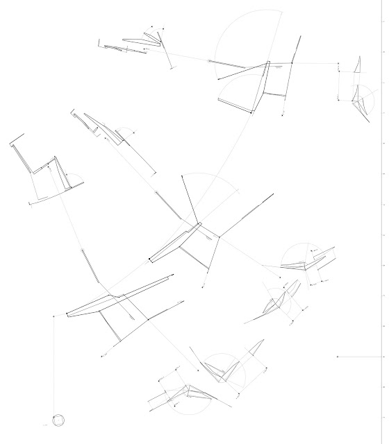
Growing complexity
This drawing focuses on urban layers.
When considered in a Cartesian coordinate system, urbanity is growing almost exclusively in the
X-, Y-direction and negligible in the Z-direction.
I would like to postulate an additional neutral value for Z, where a new two-dimensionality can take shape.
 |
Multiple layers, scales, tecniques and viewpoints combined. 110x56 cm
|
Archipelago over Amsterdam | Project description
(Swedish version)
Jag har ett stort intresse för de frågeställningar som kopplar samman det abstrakta och det konkreta. Där koncept tar fysisk kropp, statuerar skala och relaterar till kontext på ett spekulativt sätt utan att tappa sin abstraktion. Där faktiska omständigheter och idéer har vävts samman.
Hur kan det abstrakta ta form?
I detta projekt relaterar jag till de strategier och till den postulerade kontext som Metabolisterna och Archigram schematiskt utvecklade kring det adaptiva och flexibla stadsbyggandet. Jag prövar att applicera detta på en geografisk plats, vilken betraktas med fokus på egenskap och karaktär snarare än struktur och rationalitet, därför tas, ur en synvinkel ingen hänsyn till platsen samtidigt som den, ur en annan fullständigt respekteras. Konceptet är riktat mot densitetsökning utan att bryta upp den existerande staden.
Med inspiration av Yona Friedmans studier i Ville Spatiale (1958-nu), som ständigt blev utopi-stämplade, men som han tålmodigt försvarade som realiserbara, vill jag uppfinna nya sätt att leva och därigenom bryta ramar för hur arkitektur och stadssammanhang, enligt modernistiska regler ska vara.
Jag vill skapa nya organiseringar som inte följer dessa konventioner, som omprövar arkitekturens traditionsenliga relation till markplanet och planlägger urbaniteten för det 21a århundradet.
I mitt projekt så skapar jag en prototyp för en ny maskinell struktur. Denna har som motiv att intensifiera och förtäta en urban situation där det inte längre finns någon markyta att bebygga.
11.18.2011

11.16.2011
Sarah Brighton
Unit 21, taught by Abigail Ashton and Andrew Porter of Ashton Porter Architects 2009-2010
 |
| via: the Bartlett School of Architecture |
11.15.2011


11.14.2011
Atelier Bow-Wow | Louisiana
I found some nice pictures I took of Atelier Bow-Wow presentation boards that were exhibited at Louisiana Museum of Modern Art in Denmark on the exhibition Living: Frontiers of Architecture III-IV that has been on during this summer.
I am looking forward to visit the museum soon again for the Ai Weiwei exhibition that is on right now.


I am looking forward to visit the museum soon again for the Ai Weiwei exhibition that is on right now.


11.11.2011
How to draw like Borges writes
This drawing is made by Luke Caspar Pearson in 2005, and it represents one of his projects as seen through the Aleph. It's always nice to see people go outside the norm of drawing plan, section and elevation in the classic, strict and schematic manner.
 |
| via: Alephograph |
11.09.2011


CJ Lim | Sky Transport for London (2007)
Designed by CJ Lim, Sarah Custance and Maxwell Mutanda.
"The project seeks to reconfigure London Underground's Circle Line, lifting the footprint of its tracks above ground as a continuous "sky-river" through the great metropolis. Long narrow boats usually with a crew of twenty two would traverse this urban "sky-river" offering a low-carbon, environmentally efficient way for corporate employees to get to and from work as well as catch up on some much needed exercise. Apart from the daily commute this system will play host to an annual race in the Dragon Boat Festival tradition on the fifth day of the fifth month each year pitting teams taken from across London's boroughs in races across the city."
 |
| via: CJ Lim Studio 8 Architects |
Wish me luck
Now you can see all entries on the competition website. I've browsed through all of them and feel narcissistically confident in my project. The first thing I think that I can fall upon is the lack of renderings in my project. I made an active choice not to do any renderings, to make the narrative and line drawings communicate the atmosphere in a more phenomenologic manner.
Hopefully the jury will take some time for my original text and be able to see my trajectory clearly.

Hopefully the jury will take some time for my original text and be able to see my trajectory clearly.

11.07.2011


Trying to obey the teacher
... without much luck.
Sequential transformation.
Section, plan and fractal
Sequential transformation.
Section, plan and fractal


11.03.2011
10.28.2011
Metabolism | Fantastic combination of utopia and dystopia
 |
Tange Kenzo, A Plan for Tokyo 19601961. Photo: Kawasumi Akio. Photo courtesy: TANGE ASSOCIATES
|
 |
| Kikutake Kiyonori, Marine City, 1963 |
 |
| Kurokawa Kisyo, Nakagin Capsule Tower Building, Tokyo, 1972. Photo: Ohashi Tomio Pictures via: Domus |

10.26.2011
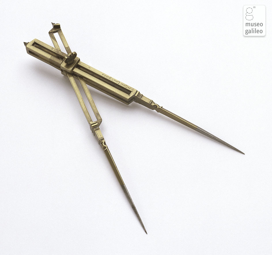
Engineering in the 17th Century
"The term "compass" or "compasses" denotes a wide range of instruments for drawing, measurement, and proportional calculation. Besides the more common compasses for drawing circumferences, widespread since antiquity, the Renaissance has left us a great number of special compasses, whose names reflect their specific functions: oval compasses to draw ellipses, hyperbolas and parabolas; two-point compasses—also called dividers—to divide lines and transfer measurements; nautical compasses, to track routes on sea-charts; compasses with curved points, called gunner's compasses, to measure mouths of cannons, cannon balls, and columns; three-legged compasses to reproduce maps; four-point compasses, or reduction compasses, to enlarge or reduce drawings, divide lines and circumferences proportionally, and draw polygons; eight-point compasses to measure fractions of degrees and carry out proportional calculations; proportional compasses to perform arithmetic, geometric, and trigonometric calculations and to measure weights, gradients, and distances for military use; and sophisticated surveying compasses that combined a magnetic compass, a windrose, and optical sights for surveying and for drawing topographic maps."
-Museo Galileo
-Museo Galileo
